Wonderland Trail
Mount Rainier National Park, Washington
86.4 miLength
24,580 ftElevation gain
StrenuousDifficulty
LoopRoute
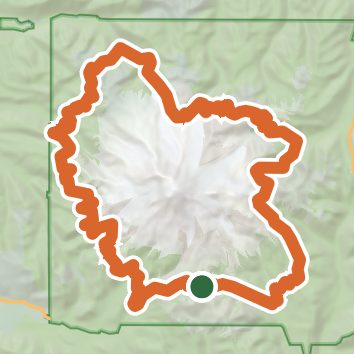
A loop of 86.4 mi in Mount Rainier Wilderness, Mount Rainier National Park.
It gains 24,580 ft of elevation in all, between a low point of 2,440 ft and a high point of 6,780 ft about 69.4 mi in.
The steepest stretch is between 46.6 mi and 47.1 mi from the trailhead, gaining 590 ft.
On the way it passes near Martha Falls, Madcap Falls, Carter Falls.
Described from the map and elevation data.
Open in Sahale GPS
See the trail on the map, download it for offline use and record your hike. The iPhone and Android apps are on their way.
Before you go: trail information can be out of date or wrong, and a trail may be closed or on private land. Check current conditions with the land manager. You hike at your own risk. Full notice
On this hike
- Lakes on this hike: Aurora Lake, Kiya Lake, Mowich Lake, Mystic Lake, Golden Lakes, Reflection Lakes, and 3 more
- Waterfalls on this hike: Martha Falls, Madcap Falls, Carter Falls, Sylvia Falls, Ipsut Falls, Garda Falls, Wauhaukaupauken Falls, Middle Steven's Creek Falls
- Rivers and creeks on this hike: Carbon River, Crater Creek, Devils Dream Creek, Fryingpan Creek, Ipsut Creek, Kautz Creek, and 4 more
- Viewpoints on this hike: Glacier Viewpoint, 4 unnamed viewpoints
Elevation profile
Low 2,440 ft86.3 miHigh 6,780 ft
Nearby trails
- Lane Peak4.3 mi · Hard · same trailhead
- Pinnacle Peak Trail2.8 mi · Moderate · same trailhead
- Mazama Ridge Trail4.1 mi · Moderate · 0.3 mi away
- High Lakes Trail2.8 mi · Moderate · 0.7 mi away
- Bench Lake1.4 mi · Easy · 1.0 mi away
- Unicorn Peak4.5 mi · Hard · 1.0 mi away
Camping nearby
- Cougar Rock Campground3.1 mi from the trailhead
- Cougar Rock Group Campground3.1 mi from the trailhead
- Ohanapecosh Group Campground7.9 mi from the trailhead
- Ohanapecosh Campground7.9 mi from the trailhead