CDT - Wyoming Section
Wyoming
A one-way trail of 503.2 mi in Bridger Wilderness, Bridger-Teton National Forest.
It goes up and down rather than rising steadily: about 52,410 ft of elevation gain along the way, between 6,520 ft and 11,110 ft, ending near Sapphire Pool.
The steepest stretch is between 9.6 mi and 10.1 mi from the trailhead, gaining 450 ft.
On the way it passes near Mirror Lake, August Lake, Bobs Lake.
Hog Park Campground is within 2 mi of the trailhead.
Described from the map and elevation data.
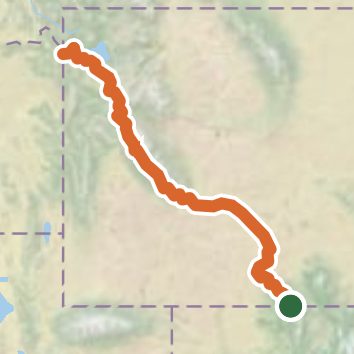
See the trail on the map, download it for offline use and record your hike. The iPhone and Android apps are on their way.
Before you go: trail information can be out of date or wrong, and a trail may be closed or on private land. Check current conditions with the land manager. You hike at your own risk. Full notice
On this hike
- Lakes on this hike: Lewis Lake, Pipestone Lakes, Shoshone Lake, Dads Lake, Middle Jean Lake, Sandpoint Lake, and 23 more
- Waterfalls on this hike: 1 unnamed waterfall
- Rivers and creeks on this hike: Big Sandy River, Coal Creek, Dads Creek, Dead Ox Creek, Elbow Creek, Firehole River, and 18 more
- Viewpoints on this hike: Gunsight Pass
Elevation profile
Nearby trails
- Hog Park Trail3 mi · Easy · 1.4 mi away
- Huston Park Trail8.6 mi · Hard · 7.9 mi away
- Green Mountain Trail3.7 mi · Moderate · 7.9 mi away
- Green Mountain Falls Trail2.4 mi · Easy · 10.6 mi away
- Purgatory Gulch Trail4.1 mi · Moderate · 11.2 mi away
- Baby Lake Trail3.3 mi · Moderate · 11.5 mi away
Camping nearby
- Hog Park Campground1.6 mi from the trailhead
- CDT crossing campsite4.3 mi from the trailhead
- Hahns Peak Lake Campground - Medicine-Bow Routt NF (CO)13.1 mi from the trailhead
- Big Creek Lakes Campground13.8 mi from the trailhead