Moss Lake Trail
Popo Agie Wilderness, Wyoming
An out-and-back in Popo Agie Wilderness, Shoshone National Forest, 30.3 mi round trip.
It goes up and down rather than rising steadily: about 3,970 ft of elevation gain on the way out, between 9,290 ft and 11,930 ft, ending near Vernal Lake.
The steepest stretch is between 13.1 mi and 13.6 mi from the trailhead, gaining 410 ft.
On the way it passes near Moss Lake, Dutch Oven Lake, Little Valentine Lake.
The trailhead is about 17.1 mi west of Lander in a straight line.
Described from the map and elevation data.
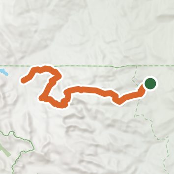
See the trail on the map, download it for offline use and record your hike. The iPhone and Android apps are on their way.
Before you go: trail information can be out of date or wrong, and a trail may be closed or on private land. Check current conditions with the land manager. You hike at your own risk. Full notice
On this hike
- Lakes on this hike: Dutch Oven Lake
Elevation profile
Nearby trails
- South Fork Lakes Trail24.1 mi · Strenuous · same trailhead
- Onion Meadows Trail31.6 mi · Strenuous · same trailhead
- Lizard Head Trail27.4 mi · Strenuous · same trailhead
- Bears Ears Trail33.7 mi · Strenuous · same trailhead
- Smith Lake Trail13 mi · Strenuous · 1.7 mi away
- North Fork Trail28.4 mi · Strenuous · 1.7 mi away
Camping nearby
- Worthen Meadow Campground12.7 mi from the trailhead
- Fremont County Youth Camp13.7 mi from the trailhead
- Frye Lake Campground13.8 mi from the trailhead
- Sinks Canyon Campground14.2 mi from the trailhead