John Muir Trail
California
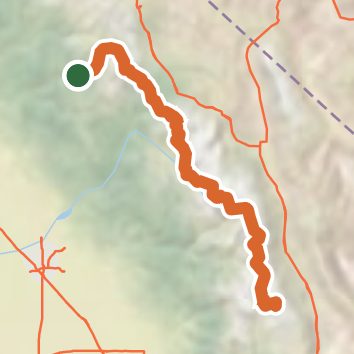
A one-way trail of 208.7 mi in Ansel Adams Wilderness, Kings Canyon National Park.
It goes up and down rather than rising steadily: about 46,130 ft of elevation gain along the way, between 4,030 ft and 14,480 ft, ending near Mount Whitney.
The steepest stretch is between 11.1 mi and 11.6 mi from the trailhead, gaining 490 ft.
On the way it passes near Timberline Lake, Nevada Falls Loop, Nevada Fall.
Tuolumne Meadows Campground is within 2 mi of the trailhead.
Described from the map and elevation data.
See the trail on the map, download it for offline use and record your hike. The iPhone and Android apps are on their way.
Before you go: trail information can be out of date or wrong, and a trail may be closed or on private land. Check current conditions with the land manager. You hike at your own risk. Full notice
On this hike
- Summits on this hike: Mount Whitney, S'brutal Tower, Mount Muir
- Lakes on this hike: Heart Lake, Middle Rae Lake, Thousand Island Lake, Upper Rae Lake, Wanda Lake, Lower Palisade Lake, and 22 more
- Waterfalls on this hike: Nevada Falls Loop, Nevada Fall, Upper Evolution Creek Falls, 1 unnamed waterfall
- Rivers and creeks on this hike: Bear Creek, Bubbs Creek, Crater Creek, Evolution Creek, Fish Creek, Lyell Fork, and 15 more
- Viewpoints on this hike: Clark Point, 8 unnamed viewpoints
Elevation profile
Nearby trails
- Cathedral Lakes Trail0.9 mi · Easy · 0.7 mi away
- Nelson Lake Use Trail10.6 mi · Strenuous · 0.7 mi away
- Elizabeth Lake Trail5 mi · Moderate · 0.7 mi away
- Soda Spring Acesss0.8 mi · Easy · 0.8 mi away
- Young Lakes Trail12.6 mi · Strenuous · 0.9 mi away
- PCT - California Section I72.2 mi · Strenuous · 1.0 mi away
Camping nearby
- Tuolumne Meadows Campground0.5 mi from the trailhead
- Tioga Lake Campground7.4 mi from the trailhead
- Junction Campground7.9 mi from the trailhead
- Sawmill Walk-in Campground8.1 mi from the trailhead