PCT - Washington Section J
Alpine Lakes Wilderness, Washington
A one-way trail of 72.2 mi in Alpine Lakes Wilderness, Mount Baker-Snoqualmie National Forest.
It goes up and down rather than rising steadily: about 15,020 ft of elevation gain along the way, between 2,970 ft and 5,990 ft, ending near Ridge Lake.
The steepest stretch is between 15.8 mi and 16.3 mi from the trailhead, gaining 410 ft.
On the way it passes near Mig Lake, Daisy Lake, Lake Susan Jane.
Described from the map and elevation data.
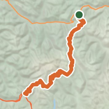
See the trail on the map, download it for offline use and record your hike. The iPhone and Android apps are on their way.
Before you go: trail information can be out of date or wrong, and a trail may be closed or on private land. Check current conditions with the land manager. You hike at your own risk. Full notice
On this hike
- Lakes on this hike: Mig Lake, Lake Susan Jane, Deception Lakes, Daisy Lake, Hope Lake, Ridge Lake
- Waterfalls on this hike: 1 unnamed waterfall
- Viewpoints on this hike: Kendall Katwalk, 1 unnamed viewpoint
Elevation profile
Nearby trails
- PCT - Washington Section K124.8 mi · Strenuous · same trailhead
- Grace Lakes Trail3.2 mi · Moderate · 0.3 mi away
- "Caboose" Nordic Ski Path0.6 mi · Easy · 1.5 mi away
- Chain Lakes Trail24.6 mi · Strenuous · 1.5 mi away
- Iron Goat Trail16.9 mi · Hard · 1.8 mi away
- "Guthrie Heights" Nordic Ski Path2.1 mi · Easy · 2.3 mi away
Camping nearby
- Rainy Creek Campground9.3 mi from the trailhead
- Soda Springs Campground9.5 mi from the trailhead
- Evergreen Mountain Lookout10.3 mi from the trailhead
- White Pine Campground10.5 mi from the trailhead