PCT - Washington Section K
Glacier Peak Wilderness, Washington
A one-way trail of 124.8 mi in Henry M. Jackson Wilderness, North Cascades National Park South Unit.
It goes up and down rather than rising steadily: about 26,060 ft of elevation gain along the way, between 1,530 ft and 6,520 ft, ending near Rainy Lake.
The steepest stretch is between 47.4 mi and 47.9 mi from the trailhead, gaining 450 ft.
On the way it passes near Reflection Pond, Lake Sally Ann, Kid Pond.
Described from the map and elevation data.
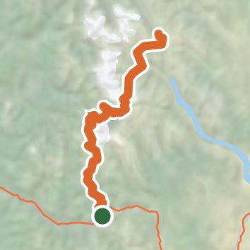
See the trail on the map, download it for offline use and record your hike. The iPhone and Android apps are on their way.
Before you go: trail information can be out of date or wrong, and a trail may be closed or on private land. Check current conditions with the land manager. You hike at your own risk. Full notice
On this hike
- Summits on this hike: Grizzly Peak
- Lakes on this hike: Lake Sally Ann, Mica Lake, Pear Lake, Lake Janus
- Rivers and creeks on this hike: Bridge Creek, Glacier Creek, Milk Creek, South Fork Agnes Creek
Elevation profile
Nearby trails
- PCT - Washington Section J72.2 mi · Strenuous · same trailhead
- Grace Lakes Trail3.2 mi · Moderate · 0.3 mi away
- "Caboose" Nordic Ski Path0.6 mi · Easy · 1.5 mi away
- Chain Lakes Trail24.6 mi · Strenuous · 1.5 mi away
- Iron Goat Trail16.9 mi · Hard · 1.8 mi away
- "Guthrie Heights" Nordic Ski Path2.1 mi · Easy · 2.3 mi away
Camping nearby
- Rainy Creek Campground9.3 mi from the trailhead
- Soda Springs Campground9.5 mi from the trailhead
- Evergreen Mountain Lookout10.3 mi from the trailhead
- White Pine Campground10.5 mi from the trailhead